Hi Nick,
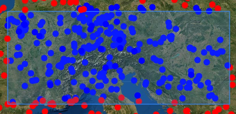
We agree that this is not expected behavior, but it is indeed the response from MongoDB. I created BeanMetadata and a DataObject with your specified Point. I issued a query using LEAF’s Java API:
        Polygon bbox = Polygon.newBuilder()
                .withExterior(List.of(
                        Position.of(0.849607, 43.447224),
                        Position.of(23.23242, 43.447224),
                        Position.of(23.23242, 49.873922),
                        Position.of(0.849607, 49.873922),
                        Position.of(0.849607, 43.447224)
                ))
                .build();
        DataObjectQuery query1 = dataObjectQuery(types("GeoType"), geoWithin("location", bbox));
        List<DataObject> results1 = dataObjectService.load(query1, Context.makeSystemContext());
And the DataObject with your outside Point coordinate was unexpectedly returned as a result. Changing its latitude to 50.5 places it sufficiently outside the bounding Polygon that it is no longer returned.
I directly queried the MongoDB database with the equivalent Mongo query:
{
    "$and": [
      {
        "location": {
          "$geoWithin": {
            "$geometry": {
              "type": "Polygon",
              "coordinates": [
                [
                    [ 0.849607, 43.447224],
                    [23.23242,  43.447224],
                    [23.23242,  49.873922],
                    [ 0.849607, 49.873922],
                    [ 0.849607, 43.447224]
                ]
              ]
            }
          }
        }
      },
      {
        "type": {
          "$in": [
            "GeoType"
          ]
        }
      }
    ]
  }
And, sure enough, Mongo returns this DataObject, which is unquestionably outside that bounding rectangular Polygon. I’ve confirmed the same results whether the location field is indexed or not (LEAF creates a 2dsphere index). And I have confirmed that you specified the positions of the bounding Polygon in the correct counter-clockwise order. I tested with MongoDB 4.0 and 4.2.
I tried your mitigation technique - adding additional points to the bounding Polygon - and directly queried MongoDB:
              "coordinates": [
                [
                    [ 0.849607, 43.447224],
                    [10.0,      43.447224],
                    [20.0,      43.447224],
                    [23.23242,  43.447224],
                    [23.23242,  49.873922],
                    [20.0,      49.873922],
                    [10.0,      49.873922],
                    [ 0.849607, 49.873922],
                    [ 0.849607, 43.447224]
                ]
              ]
…and now your outside-Point is correctly excluded!
LEAF relies on the database for geospatial querying, and in this case - as best as we’re able to tell - it appears as if Mongo’s $geoWithin query operator is inaccurate with some edge cases.
I switched to a SQL-backed LEAF data service, and - with the original code - your outside Point is correctly excluded.
We’ll investigate further to see if we can come up with a more satisfactory explanation for MongoDB’s behavior here, but in the meantime it looks like its accuracy may be related to the sparseness of the bounding Polygon, and your mitigation - defining additional positions when covering large areas, even for a rectangle(!) - is advised. Or, if it meets your application’s requirements, you may wish to use a SQL database backed DataObjectService (eg: PostgreSQL) instead.